
Horseshoe Lake topographic map
Interactive map
Click on the map to display elevation.
About this map
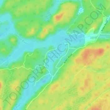
Name: Horseshoe Lake topographic map, elevation, terrain.
Average elevation: 201 m
Minimum elevation: 182 m
Maximum elevation: 224 m
Other topographic maps
Click on a map to view its topography, its elevation and its terrain.
Salmon Lake
Canada > Ontario > Central Frontenac
Salmon Lake, Central Frontenac, Frontenac County, Eastern Ontario, Ontario, Canada
Average elevation: 225 m
Godfrey
Canada > Ontario > Central Frontenac > Godfrey
Godfrey, Central Frontenac, Frontenac County, Eastern Ontario, Ontario, Canada
Average elevation: 169 m
Fraser Lake
Canada > Ontario > Central Frontenac
Fraser Lake, Pitt Road, Central Frontenac, Lennox and Addington County, Eastern Ontario, Ontario, K0H 1B0, Canada
Average elevation: 223 m