
Ciudad Real topographic map
Interactive map
Click on the map to display elevation.
About this map
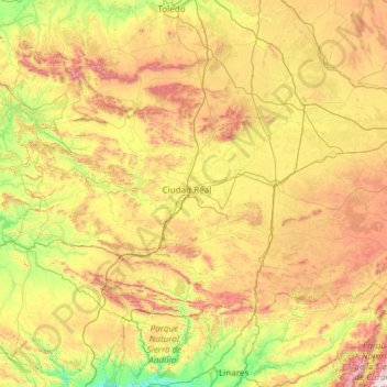
Name: Ciudad Real topographic map, elevation, terrain.
Location: Ciudad Real, Castile-La Mancha, Spain (38.34276 -5.04695 39.57676 -2.63649)
Average elevation: 683 m
Minimum elevation: 182 m
Maximum elevation: 1,884 m
The province of Ciudad Real is located in central Spain and is the third largest province in the country with an area of 19,813 km2 (7,650 sq mi). To the north lies the Province of Toledo, to the northeast the Province of Cuenca, to the east the Province of Albacete, to the south lie the Provinces of Córdoba and Jaén, and to the west the Province of Badajoz. To the northwest of the province is a separate area, the exclave of Anchuras, which is sandwiched between the Province of Badajoz and the Province of Toledo. The provincial capital is Ciudad Real. Part of the province is part of the plateau of La Mancha, an elevated but fertile area averaging 500 to 600 metres (1,600 to 2,000 ft) above sea level, the highest elevation being in the comarca of Campo de Montiel at 900 metres (2,950 ft). The main river, crossing the province from east to west, is the Guadiana, and its right bank tributary, the Cigüela.
Other topographic maps
Click on a map to view its topography, its elevation and its terrain.
Talavera de la Reina
Talavera de la Reina, Castile-La Mancha, Spain
Average elevation: 453 m
Mora
Spain > Castile-La Mancha > Mancha Alta de Toledo
Mora, Mancha Alta de Toledo, Toledo, Castile-La Mancha, 45400, Spain
Average elevation: 717 m
San Clemente
San Clemente, Cuenca, Castile-La Mancha, 16600, Spain
Average elevation: 743 m
Río Guadiana
Spain > Castile-La Mancha > La Mancha > Daimiel
Río Guadiana, Daimiel, La Mancha, Ciudad Real, Castile-La Mancha, Spain
Average elevation: 617 m
sinkhole
Spain > Castile-La Mancha > Pajarón
sinkhole, Pajarón, Cuenca, Castile-La Mancha, Spain
Average elevation: 1,042 m
Tagus
Spain > Castile-La Mancha > Azután
Tagus, Azután, Campana de Oropesa, Toledo, Castile-La Mancha, 28300, Spain
Average elevation: 622 m
Herrería
Spain > Castile-La Mancha > Herrería
Herrería, Guadalajara, Castile-La Mancha, Spain
Average elevation: 1,187 m
Galápagos
Spain > Castile-La Mancha > Galápagos
Galápagos, Guadalajara, Castile-La Mancha, Spain
Average elevation: 794 m