
Hat Yai topographic map
Interactive map
Click on the map to display elevation.
About this map
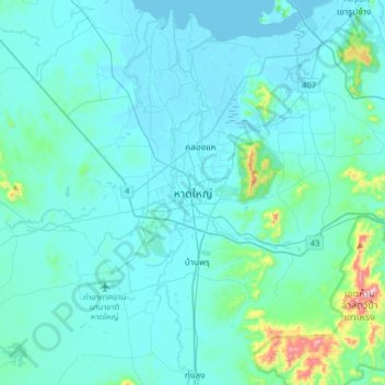
Name: Hat Yai topographic map, elevation, terrain.
Location: Hat Yai, Kho Hong, Songkhla Province, Thailand (6.84746 100.30899 7.16746 100.62899)
Average elevation: 47 m
Minimum elevation: -2 m
Maximum elevation: 524 m
Other topographic maps
Click on a map to view its topography, its elevation and its terrain.
Khao Rup Chang
Khao Rup Chang, Phawong, Songkhla Province, 90000, Thailand
Average elevation: 21 m
Ban La Nga
Ban La Nga, Ban Na, Songkhla Province, Thailand
Average elevation: 10 m