
Pittwater topographic map
Interactive map
Click on the map to display elevation.
About this map
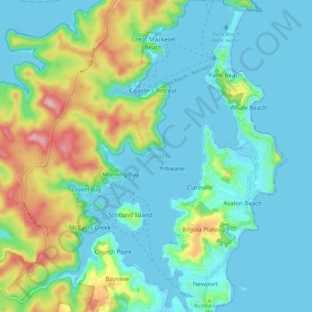
Name: Pittwater topographic map, elevation, terrain.
Average elevation: 50 m
Minimum elevation: -4 m
Maximum elevation: 215 m
Other topographic maps
Click on a map to view its topography, its elevation and its terrain.
Cherrybrook
Cherrybrook, Sydney, The Council of the Shire of Hornsby, 2126, Australia
Average elevation: 159 m
Blue Mountains National Park
Blue Mountains National Park, View Street, East Blaxland, Blaxland, Sydney, Blue Mountains City Council, 2774, Australia
Average elevation: 456 m