
Malpeque topographic map
Interactive map
Click on the map to display elevation.
About this map
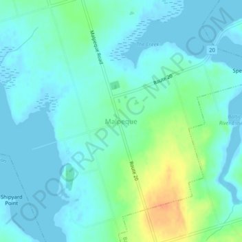
Name: Malpeque topographic map, elevation, terrain.
Average elevation: 9 m
Minimum elevation: -2 m
Maximum elevation: 37 m
Other topographic maps
Click on a map to view its topography, its elevation and its terrain.
Summerside
Canada > Prince Edward Island > Summerside
Summerside, Prince County, Prince Edward Island, C1N 2Z4, Canada
Average elevation: 13 m
New Annan
Canada > Prince Edward Island > Summerside
New Annan, Summerside, Prince County, Prince Edward Island, C1N 5J5, Canada
Average elevation: 14 m