
Sedona topographic map
Interactive map
Click on the map to display elevation.
About this map
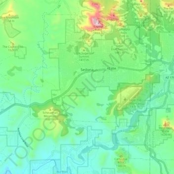
Name: Sedona topographic map, elevation, terrain.
Location: Sedona, Yavapai County, Arizona, 86336, United States (34.81807 -111.84819 34.89021 -111.74289)
Average elevation: 1,342 m
Minimum elevation: 1,141 m
Maximum elevation: 1,930 m
Sedona interior chaparral has many shrubs and small tree species of Quercus turbinella, Rhus ovata, and a large population of Quercus palmeri. The Great Basin woodland has many small to medium trees of Pinus monopylla Var. fallax, Juniperus arizonica, Juniperus deppeana, Juniperus osteosperma, Juniperus monosperma,a large population of Cupressus glabra. At higher elevations in oak creek canyon Juniperus virginiana, Pinus edulis, and other pines occur.
Other topographic maps
Click on a map to view its topography, its elevation and its terrain.
Prescott
United States > Arizona > Yavapai County
Prescott, Yavapai County, Arizona, United States
Average elevation: 1,674 m
Chino Valley
United States > Arizona > Yavapai County
Chino Valley, Yavapai County, Arizona, 86323, United States
Average elevation: 1,454 m
Black Canyon City
United States > Arizona > Yavapai County
Black Canyon City, Yavapai County, Arizona, 85324, United States
Average elevation: 763 m
Ash Fork
United States > Arizona > Yavapai County > Ash Fork
Ash Fork, Yavapai County, Arizona, 86320, United States
Average elevation: 1,561 m
Cottonwood
United States > Arizona > Yavapai County
Cottonwood, Yavapai County, Arizona, United States
Average elevation: 1,118 m
Prescott Valley
United States > Arizona > Yavapai County
Prescott Valley, Yavapai County, Arizona, United States
Average elevation: 1,550 m