
Bray Lake topographic map
Interactive map
Click on the map to display elevation.
About this map
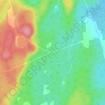
Name: Bray Lake topographic map, elevation, terrain.
Average elevation: 369 m
Minimum elevation: 325 m
Maximum elevation: 437 m
Other topographic maps
Click on a map to view its topography, its elevation and its terrain.
Eagle Lake
Canada > Ontario > Machar Township
Eagle Lake, Riding Ranch Road, Machar Township, Parry Sound District, Central Ontario, Ontario, P0A 1X0, Canada
Average elevation: 373 m
Mikisew Provincial Park
Canada > Ontario > Machar Township
Mikisew Provincial Park, Machar Township, Parry Sound District, Central Ontario, Ontario, Canada
Average elevation: 371 m