
Prescott topographic map
Interactive map
Click on the map to display elevation.
About this map
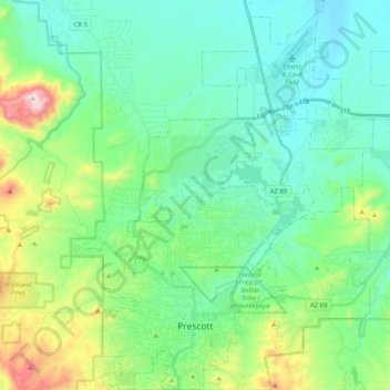
Name: Prescott topographic map, elevation, terrain.
Location: Prescott, Yavapai County, Arizona, United States (34.51253 -112.52996 34.67994 -112.37610)
Average elevation: 1,674 m
Minimum elevation: 1,486 m
Maximum elevation: 2,302 m
Prescott is in the Bradshaw Mountains of central Arizona, at an elevation of 5,400 feet (1,600 m). The city has a Mediterranean climate (Köppen Csa); however, unlike most other locations in this climate class, there is a pronounced summer wet season due to the North American Monsoon.
Other topographic maps
Click on a map to view its topography, its elevation and its terrain.
Chino Valley
United States > Arizona > Yavapai County
Chino Valley, Yavapai County, Arizona, 86323, United States
Average elevation: 1,454 m
Black Canyon City
United States > Arizona > Yavapai County
Black Canyon City, Yavapai County, Arizona, 85324, United States
Average elevation: 763 m
Ash Fork
United States > Arizona > Yavapai County > Ash Fork
Ash Fork, Yavapai County, Arizona, 86320, United States
Average elevation: 1,561 m
Cottonwood
United States > Arizona > Yavapai County
Cottonwood, Yavapai County, Arizona, United States
Average elevation: 1,118 m
Prescott Valley
United States > Arizona > Yavapai County
Prescott Valley, Yavapai County, Arizona, United States
Average elevation: 1,550 m
Sedona
United States > Arizona > Yavapai County
Sedona, Yavapai County, Arizona, 86336, United States
Average elevation: 1,342 m