
Hobart topographic map
Interactive map
Click on the map to display elevation.
About this map
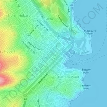
Name: Hobart topographic map, elevation, terrain.
Location: Hobart, City of Hobart, Tasmania, 7000, Australia (-42.89164 147.31561 -42.87305 147.34150)
Average elevation: 31 m
Minimum elevation: -2 m
Maximum elevation: 147 m
Although Hobart itself rarely receives snow during the winter due to the foehn effect created by the Central Highlands (the city's geographic position causes a rainshadow), the adjacent Kunanyi/Mount Wellington is frequently seen with a snowcap throughout the year including in summer. During the 20th century, the city itself has received snowfalls at sea level on average only once every 5 years; however, outer suburbs lying higher on the slopes of Mount Wellington receive snow more often, owing to the more exposed position coupled with them resting at higher altitude. These snow-bearing winds often carry on through Tasmania and Victoria to the Snowy Mountains in Victoria and southern New South Wales.
Other topographic maps
Click on a map to view its topography, its elevation and its terrain.
Freycinet Peninsula
Freycinet Peninsula, Glamorgan-Spring Bay, Tasmania, Australia
Average elevation: 303 m
Adventure Bay
Adventure Bay, Kingborough, Tasmania, 7150, Australia
Average elevation: 110 m
Broad River
Australia > Tasmania > Ellendale
Broad River, Ellendale, Central Highlands, Tasmania, 7140, Australia
Average elevation: 709 m
Seymour Conservation Area
Australia > Tasmania > Seymour
Seymour Conservation Area, Seymour, Break O'Day, Tasmania, Australia
Average elevation: 19 m
Oyster Cove
Oyster Cove, Kingborough, Tasmania, Australia
Average elevation: 142 m
Cockle Creek
Australia > Tasmania > Recherche
Cockle Creek, Recherche, Huon Valley, Tasmania, Australia
Average elevation: 64 m
Launceston
Launceston, City of Launceston, Tasmania, 7250, Australia
Average elevation: 26 m
Anderson Island
Anderson Island, Flinders Council, Tasmania, Australia
Average elevation: 4 m
Lower Longley
Australia > Tasmania > Lower Longley
Lower Longley, Tasmania, Australia
Average elevation: 351 m
Breadalbane
Australia > Tasmania > Breadalbane
Breadalbane, Tasmania, 7212, Australia
Average elevation: 176 m
Reedy Marsh
Australia > Tasmania > Reedy Marsh
Reedy Marsh, Tasmania, Australia
Average elevation: 290 m
Randalls Bay
Australia > Tasmania > Randalls Bay
Randalls Bay, Tasmania, Australia
Average elevation: 49 m
Bathurst Harbour
Bathurst Harbour, Mount Beattie Track, Tasmania, Australia
Average elevation: 139 m