
Farmington topographic map
Interactive map
Click on the map to display elevation.
About this map
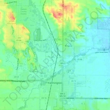
Name: Farmington topographic map, elevation, terrain.
Location: Farmington, Dakota County, Minnesota, 55024, United States (44.62329 -93.20763 44.69217 -93.11639)
Average elevation: 280 m
Minimum elevation: 266 m
Maximum elevation: 316 m
Other topographic maps
Click on a map to view its topography, its elevation and its terrain.
Apple Valley
United States > Minnesota > Dakota County
Apple Valley, Dakota County, Minnesota, 55124, United States
Average elevation: 301 m
Lakeville
United States > Minnesota > Dakota County
Lakeville, Dakota County, Minnesota, 55044, United States
Average elevation: 305 m
Eagan
United States > Minnesota > Dakota County
Eagan, Dakota County, Minnesota, United States
Average elevation: 267 m
Hastings
United States > Minnesota > Dakota County > Hastings > Hastings
Hastings, Dakota County, Minnesota, 55033, United States
Average elevation: 243 m
Burnsville
United States > Minnesota > Dakota County > Burnsville
Burnsville, Dakota County, Minnesota, United States
Average elevation: 271 m
Rosemount
United States > Minnesota > Dakota County > Rosemount
Rosemount, Dakota County, Minnesota, 55068, United States
Average elevation: 287 m