
Amnat Charoen Province topographic map
Interactive map
Click on the map to display elevation.
About this map
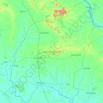
Name: Amnat Charoen Province topographic map, elevation, terrain.
Location: Amnat Charoen Province, Thailand (15.54225 104.41909 16.27926 105.06001)
Average elevation: 156 m
Minimum elevation: 114 m
Maximum elevation: 443 m
Other topographic maps
Click on a map to view its topography, its elevation and its terrain.
Phana
Thailand > Amnat Charoen Province > Phana
Phana, Amnat Charoen Province, Thailand
Average elevation: 132 m
Ban Khok Chakkachan
Thailand > Amnat Charoen Province > Ban Khok Chakkachan
Ban Khok Chakkachan, Amnat Charoen Province, 37000, Thailand
Average elevation: 153 m
Phu Sa Dok Bua National Park
Thailand > Amnat Charoen Province > Ban Nom Klao
Phu Sa Dok Bua National Park, Ban Nom Klao, Amnat Charoen Province, Thailand
Average elevation: 184 m