
Lake Champlain topographic map
Interactive map
Click on the map to display elevation.
About this map
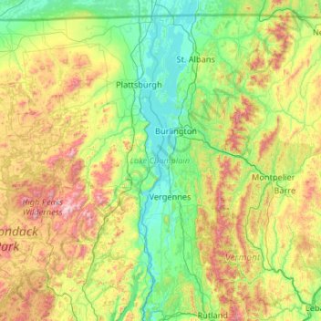
Name: Lake Champlain topographic map, elevation, terrain.
Location: Lake Champlain, Chittenden County, Vermont, United States (43.58320 -73.46064 45.08509 -73.07591)
Average elevation: 355 m
Minimum elevation: 25 m
Maximum elevation: 1,543 m
Other topographic maps
Click on a map to view its topography, its elevation and its terrain.
Mount Mansfield
United States > Vermont > Chittenden County > Underhill
Mount Mansfield, Underhill, Chittenden County, Vermont, United States
Average elevation: 914 m
Indian Lookout
United States > Vermont > Chittenden County > Williston
Indian Lookout, Williston, Chittenden County, Vermont, United States
Average elevation: 135 m
South Burlington
United States > Vermont > Chittenden County
South Burlington, Chittenden County, Vermont, United States
Average elevation: 92 m
Jericho
United States > Vermont > Chittenden County > Jericho
Jericho, Chittenden County, Vermont, 05465, United States
Average elevation: 257 m
Shelburne
United States > Vermont > Chittenden County
Shelburne, Chittenden County, Vermont, 05482, United States
Average elevation: 69 m
Burlington
United States > Vermont > Chittenden County
Burlington, Chittenden County, Vermont, United States
Average elevation: 59 m