
Ingham County topographic map
Interactive map
Click on the map to display elevation.
About this map
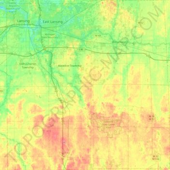
Name: Ingham County topographic map, elevation, terrain.
Location: Ingham County, Michigan, United States (42.42196 -84.60314 42.77660 -84.14060)
Average elevation: 278 m
Minimum elevation: 246 m
Maximum elevation: 319 m
The county consists of gently rolling hills with an elevation ranging between 800 and 1,000 feet above sea level. The highest point in the county is the top of Teaspoon Hill rising to a height of 1,056 feet above sea level 1.5 miles north of Leslie.
Other topographic maps
Click on a map to view its topography, its elevation and its terrain.
Gaylord
United States > Michigan > Otsego County > Gaylord
Gaylord, Otsego County, Michigan, United States
Average elevation: 401 m
Grand Rapids
United States > Michigan > Kent County
Grand Rapids, Kent County, Michigan, United States
Average elevation: 216 m
Battle Creek
United States > Michigan > Calhoun County
Battle Creek, Calhoun County, Michigan, United States
Average elevation: 274 m
Northville
United States > Michigan > Wayne County
Northville, Wayne County, Michigan, United States
Average elevation: 258 m
Big Creek Township
United States > Michigan > Oscoda County
Big Creek Township, Oscoda County, Michigan, 48636, United States
Average elevation: 350 m
Independence Charter Township
United States > Michigan > Oakland County
Independence Charter Township, Oakland County, Michigan, United States
Average elevation: 318 m
Central Lake Township
United States > Michigan > Antrim County
Central Lake Township, Antrim County, Michigan, 49622, United States
Average elevation: 226 m
Baltimore Township
United States > Michigan > Barry County
Baltimore Township, Barry County, Michigan, United States
Average elevation: 280 m
Port Huron
United States > Michigan > Saint Clair County
Port Huron, Saint Clair County, Michigan, United States
Average elevation: 185 m
Cheboygan County
Cheboygan County, Michigan, United States
Average elevation: 222 m
Houghton
United States > Michigan > Houghton County
Houghton, Houghton County, Michigan, 49931, United States
Average elevation: 269 m
Muskegon River - South Channel
United States > Michigan > Muskegon County > Muskegon
Muskegon River - South Channel, Muskegon, Muskegon Charter Township, Muskegon County, Michigan, United States
Average elevation: 188 m
Bois Blanc Township
United States > Michigan > Mackinac County
Bois Blanc Township, Mackinac County, Michigan, 49775, United States
Average elevation: 179 m
Lake Orion
United States > Michigan > Oakland County
Lake Orion, Oakland County, Michigan, 48362, United States
Average elevation: 303 m
Brownstown Charter Township
United States > Michigan > Wayne County
Brownstown Charter Township, Wayne County, Michigan, 48134, United States
Average elevation: 183 m
Charlevoix County
Charlevoix County, Michigan, United States
Average elevation: 215 m
Elmwood Township
United States > Michigan > Tuscola County
Elmwood Township, Tuscola County, Michigan, 48735, United States
Average elevation: 217 m
Sturgeon River
United States > Michigan > Dickinson County
Sturgeon River, Waucedah Township, Dickinson County, Michigan, United States
Average elevation: 306 m
Speaker
United States > Michigan > Sanilac County
Speaker, Speaker Township, Sanilac County, Michigan, 48454, United States
Average elevation: 245 m
White Lake Charter Township
United States > Michigan > Oakland County
White Lake Charter Township, Oakland County, Michigan, United States
Average elevation: 303 m
Two Lakes
United States > Michigan > Alger County
Two Lakes, Munising Township, Alger County, Michigan, United States
Average elevation: 219 m
Bloomfield Hills
United States > Michigan > Oakland County
Bloomfield Hills, Oakland County, Michigan, 48304, United States
Average elevation: 261 m
St. Clair River
United States > Michigan > SaintClair
St. Clair River, SaintClair, East China Township, Saint Clair County, Michigan, 48054-1596, United States
Average elevation: 191 m
Fife Lake Township
United States > Michigan > Grand Traverse County
Fife Lake Township, Grand Traverse County, Michigan, United States
Average elevation: 318 m
Cadillac
United States > Michigan > Wexford County
Cadillac, Wexford County, Michigan, United States
Average elevation: 404 m
Lenawee County
Lenawee County, Michigan, United States
Average elevation: 252 m
Haynes Township
United States > Michigan > Alcona County
Haynes Township, Alcona County, Michigan, United States
Average elevation: 232 m
Utica
United States > Michigan > Macomb County
Utica, Macomb County, Michigan, United States
Average elevation: 197 m
Midland County
Midland County, Michigan, United States
Average elevation: 204 m
Brooks Township
United States > Michigan > Newaygo County
Brooks Township, Newaygo County, Michigan, 49337, United States
Average elevation: 237 m
Tower
United States > Michigan > Cheboygan County
Tower, Forest Township, Cheboygan County, Michigan, 49792, United States
Average elevation: 232 m
Delta Charter Township
United States > Michigan > Eaton County
Delta Charter Township, Eaton County, Michigan, 48917, United States
Average elevation: 263 m
Shelby Township
United States > Michigan > Oceana County
Shelby Township, Oceana County, Michigan, 49455, United States
Average elevation: 261 m
Carp Lake Township
United States > Michigan > Emmet County
Carp Lake Township, Emmet County, Michigan, United States
Average elevation: 226 m
Mackinaw City
United States > Michigan > Cheboygan County
Mackinaw City, Mackinaw Township, Cheboygan County, Michigan, 49701, United States
Average elevation: 184 m
Isle Royale
United States > Michigan > Keweenaw County
Isle Royale, Keweenaw County, Michigan, United States
Average elevation: 190 m
Glen Arbor Township
United States > Michigan > South Manitou Island
Glen Arbor Township, South Manitou Island, Michigan, 49636, United States
Average elevation: 180 m
Mundy Charter Township
United States > Michigan > Genesee County
Mundy Charter Township, Genesee County, Michigan, United States
Average elevation: 251 m
Highland Charter Township
United States > Michigan > Oakland County
Highland Charter Township, Oakland County, Michigan, 48357, United States
Average elevation: 315 m
Rochester
United States > Michigan > Oakland County
Rochester, Oakland County, Michigan, United States
Average elevation: 242 m
Chesterfield Charter Township
United States > Michigan > Macomb County
Chesterfield Charter Township, Macomb County, Michigan, United States
Average elevation: 182 m
Mattawan
United States > Michigan > Van Buren County
Mattawan, Antwerp Township, Van Buren County, Michigan, 49071, United States
Average elevation: 263 m
Troy
United States > Michigan > Oakland County
Troy, Oakland County, Michigan, United States
Average elevation: 221 m
Holmes Township
United States > Michigan > Menominee County
Holmes Township, Menominee County, Michigan, United States
Average elevation: 240 m
Grand Mere State Park
United States > Michigan > Berrien County > Stevensville
Grand Mere State Park, Stevensville, Lincoln Charter Township, Berrien County, Michigan, United States
Average elevation: 185 m
Hurontown
United States > Michigan > Houghton County
Hurontown, Portage Township, Houghton County, Michigan, 49931, United States
Average elevation: 260 m
Smyrna
United States > Michigan > Ionia County
Smyrna, Otisco Township, Ionia County, Michigan, 48809, United States
Average elevation: 250 m
Shattuckville
United States > Michigan > Saginaw County
Shattuckville, Saginaw Charter Township, Saginaw County, Michigan, 48603, United States
Average elevation: 187 m