
Qinghai topographic map
Interactive map
Click on the map to display elevation.
About this map
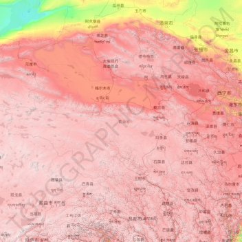
Name: Qinghai topographic map, elevation, terrain.
Location: Qinghai, China (31.60180 89.40222 39.21423 103.06941)
Average elevation: 3,710 m
Minimum elevation: 787 m
Maximum elevation: 6,545 m
The average elevation of Qinghai is over 3,000 metres (9,800 ft) above sea level.[citation needed] Mountain ranges include the Tanggula Mountains and Kunlun Mountains, with the highest point being Bukadaban Feng at 6,860 metres (22,510 ft).[31] Due to the high altitude, Qinghai has quite cold winters (harsh in the highest elevations), mild summers, and a large diurnal temperature variation. Its mean annual temperature is approximately −5 to 8 °C (23 to 46 °F), with January temperatures ranging from −18 to −7 °C (0 to 19 °F) and July temperatures ranging from 15 to 21 °C (59 to 70 °F). It is also prone to heavy winds as well as sandstorms from February to April. Significant rainfall occurs mainly in summer, while precipitation is very low in winter and spring, and is generally low enough to keep much of the province semi-arid or arid.
Other topographic maps
Click on a map to view its topography, its elevation and its terrain.
Nam Bin Wai
China > Hong Kong > Yuen Long District > Tai Kiu Village
Nam Bin Wai, Tai Kiu Village, Yuen Long District, New Territories, Hong Kong, China
Average elevation: 16 m
CN/VN disputes in Paracel Islands
CN/VN disputes in Paracel Islands, Hainan Province, 573199, China
Average elevation: 0 m
Lion mountain
China > Zhejiang > Hangzhou City
Lion mountain, Hangzhou City, Zhejiang, 310024, China
Average elevation: 15 m
Tazhong
China > Xinjiang > Qarqan County > Tazhong Town
Tazhong, Tazhong Town, Qarqan County, Bayingolin, Xinjiang, China
Average elevation: 1,116 m
Keriya County
Keriya County, Hotan Prefecture, Xinjiang, 848400, China
Average elevation: 2,410 m
Yau Oi Chuen
China > Hong Kong > Sha Tin District > Tung Lo Wan
Yau Oi Chuen, Tung Lo Wan, Sha Tin District, New Territories, Hong Kong, China
Average elevation: 156 m
Wuhua District
Wuhua District, Kunming, Yunnan, China
Average elevation: 2,104 m
Daxingnanjiecun
China > Henan > Tangyin County
Daxingnanjiecun, Tangyin County, Anyang, Henan, China
Average elevation: 85 m
Ap Lei Chau
China > Hong Kong > Hong Kong Island
Ap Lei Chau, Southern District, Hong Kong Island, Hong Kong, China
Average elevation: 25 m
Yaha
China > Gansu > Zhugqu County > Wuping
Yaha, Wuping, Zhugqu County, Gannan, Gansu, 746300, China
Average elevation: 2,174 m
Huancui District
Huancui District, Weihai, Shandong, 264200, China
Average elevation: 41 m
Tai Mo Shan
China > Hong Kong > Tsuen Wan District
Tai Mo Shan, Tsuen Wan District, New Territories, Hong Kong, China
Average elevation: 600 m
Yiwu County
Yiwu County, Hami, Yiwu, Xinjiang, China
Average elevation: 1,215 m
Kaba
China > Xinjiang > Habahe County > 阿克齐镇
Kaba, 阿克齐镇, Habahe County, Altay Prefecture, Xinjiang, China
Average elevation: 557 m