
Brainerd topographic map
Interactive map
Click on the map to display elevation.
About this map
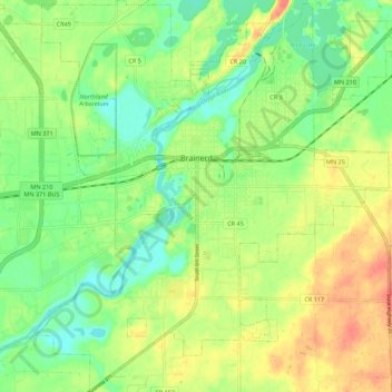
Name: Brainerd topographic map, elevation, terrain.
Location: Brainerd, Crow Wing County, Minnesota, 56401, United States (46.31263 -94.24592 46.38862 -94.14238)
Average elevation: 370 m
Minimum elevation: 348 m
Maximum elevation: 395 m
Other topographic maps
Click on a map to view its topography, its elevation and its terrain.
Duck Lake
United States > Minnesota > Crow Wing County > Crosslake
Duck Lake, Crosslake, Crow Wing County, Minnesota, United States
Average elevation: 377 m
Ruth Lake
United States > Minnesota > Crow Wing County > Emily
Ruth Lake, Emily, Crow Wing County, Minnesota, United States
Average elevation: 391 m
Pequot Terrace
United States > Minnesota > Crow Wing County > Nisswa
Pequot Terrace, Nisswa, Crow Wing County, Minnesota, 56468, United States
Average elevation: 372 m
Saint Mathias
United States > Minnesota > Crow Wing County > Saint Mathias
Saint Mathias, Crow Wing County, Minnesota, United States
Average elevation: 369 m
Emily
United States > Minnesota > Crow Wing County > Emily
Emily, Crow Wing County, Minnesota, 56447, United States
Average elevation: 393 m
Breezy Point
United States > Minnesota > Crow Wing County
Breezy Point, Crow Wing County, Minnesota, United States
Average elevation: 377 m