
Leonardtown topographic map
Interactive map
Click on the map to display elevation.
About this map
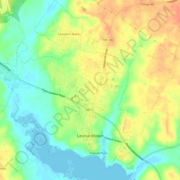
Name: Leonardtown topographic map, elevation, terrain.
Location: Leonardtown, Saint Mary's County, Maryland, United States (38.28072 -76.66651 38.32334 -76.61836)
Average elevation: 21 m
Minimum elevation: -2 m
Maximum elevation: 45 m
Other topographic maps
Click on a map to view its topography, its elevation and its terrain.
Mechanicsville
United States > Maryland > Saint Mary's County
Mechanicsville, Saint Mary's County, Maryland, 20659, United States
Average elevation: 46 m
Golden Beach
United States > Maryland > Saint Mary's County > Patuxent Knolls
Golden Beach, Patuxent Knolls, Saint Mary's County, Maryland, United States
Average elevation: 16 m
Lexington Park
United States > Maryland > Saint Mary's County
Lexington Park, Saint Mary's County, Maryland, United States
Average elevation: 20 m