
Southern Indian Lake topographic map
Interactive map
Click on the map to display elevation.
About this map
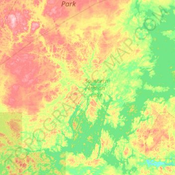
Name: Southern Indian Lake topographic map, elevation, terrain.
Average elevation: 294 m
Minimum elevation: 247 m
Maximum elevation: 421 m
Southern Indian Lake is a large lake in Manitoba, Canada. It has an area of 2,247 km2 (868 sq mi) (including islands) with a surface elevation of 258 m (846 ft).
Other topographic maps
Click on a map to view its topography, its elevation and its terrain.
O-Pipon-Na-Piwin Cree Nation
Canada > Manitoba > O-Pipon-Na-Piwin Cree Nation
O-Pipon-Na-Piwin Cree Nation, Manitoba, Canada
Average elevation: 269 m