
Plzeň topographic map
Interactive map
Click on the map to display elevation.
About this map
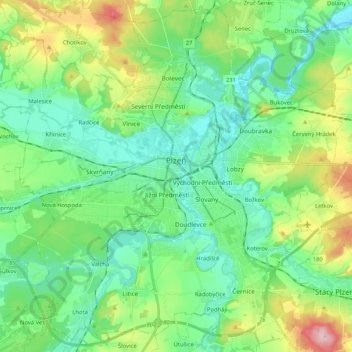
Name: Plzeň topographic map, elevation, terrain.
Location: Plzeň, okres Plzeň-město, Plzeňský kraj, Southwest, Czechia (49.67760 13.26799 49.80576 13.47584)
Average elevation: 361 m
Minimum elevation: 290 m
Maximum elevation: 553 m
Plzeň has a cool and temperate Oceanic climate (Cfb). Plzeň has low rainfall (604 mm (24 in) year average) evenly spread over the year. Precipitation occurs on average every second day, and the number of days with thunderstorms is 19. It receives on average 1,700 hours of sunshine though winters have longer periods without sunshine. Terrain features and a relatively low altitude (290 to 390 m (950 to 1,280 ft)) give some shelter from strong winds.
Other topographic maps
Click on a map to view its topography, its elevation and its terrain.
Bělá nad Radbuzou
Czechia > Southwest > Plzeňský kraj
Bělá nad Radbuzou, okres Domažlice, Plzeňský kraj, Southwest, 345 26, Czechia
Average elevation: 546 m
Česká Kubice
Czechia > Southwest > Plzeňský kraj
Česká Kubice, okres Domažlice, Plzeňský kraj, Southwest, 345 32, Czechia
Average elevation: 570 m
Kočov
Czechia > Southwest > Plzeňský kraj
Kočov, okres Tachov, Plzeňský kraj, Southwest, Czechia
Average elevation: 487 m
Železná Ruda
Czechia > Southwest > Plzeňský kraj
Železná Ruda, okres Klatovy, Plzeňský kraj, Southwest, 340 04, Czechia
Average elevation: 921 m
Modrava
Czechia > Southwest > Plzeňský kraj
Modrava, okres Klatovy, Plzeňský kraj, Southwest, Czechia
Average elevation: 1,125 m