
Glittertinden topographic map
Interactive map
Click on the map to display elevation.
About this map
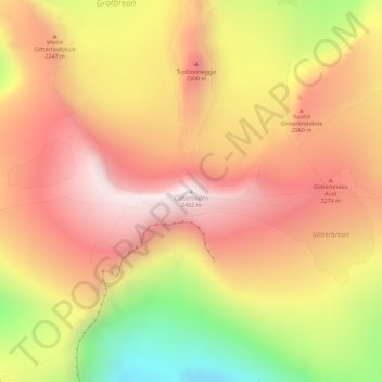
Name: Glittertinden topographic map, elevation, terrain.
Location: Glittertinden, Lom, Innlandet, Norway (61.65134 8.55773 61.65144 8.55783)
Average elevation: 2,133 m
Minimum elevation: 1,652 m
Maximum elevation: 2,454 m
Other topographic maps
Click on a map to view its topography, its elevation and its terrain.
Li
Norway > Innlandet > Skammestein
Li, Skammestein, Øystre Slidre, Innlandet, 2950, Norway
Average elevation: 774 m