
Newton-with-Clifton topographic map
Interactive map
Click on the map to display elevation.
About this map
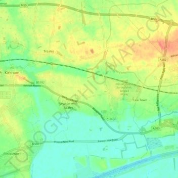
Name: Newton-with-Clifton topographic map, elevation, terrain.
Average elevation: 18 m
Minimum elevation: 0 m
Maximum elevation: 42 m
Other topographic maps
Click on a map to view its topography, its elevation and its terrain.
Main Dyke
United Kingdom > England > Fylde
Main Dyke, Fylde, Lancashire, North West England, England, FY5 5LG, United Kingdom
Average elevation: 9 m
Westby-with-Plumptons
United Kingdom > England > Fylde
Westby-with-Plumptons, Fylde, Lancashire, North West England, England, United Kingdom
Average elevation: 12 m
Saint Anne's on the Sea
United Kingdom > England > Fylde
Saint Anne's on the Sea, Fylde, Lancashire, North West England, England, United Kingdom
Average elevation: 4 m
Staining
United Kingdom > England > Fylde
Staining, Fylde, Lancashire, North West England, England, United Kingdom
Average elevation: 13 m
Greenhalgh-with-Thistleton
United Kingdom > England > Fylde
Greenhalgh-with-Thistleton, Fylde, Lancashire, North West England, England, United Kingdom
Average elevation: 20 m