
Marijampolė topographic map
Interactive map
Click on the map to display elevation.
About this map
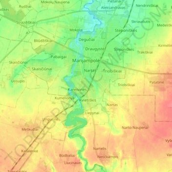
Name: Marijampolė topographic map, elevation, terrain.
Average elevation: 82 m
Minimum elevation: 56 m
Maximum elevation: 108 m
Other topographic maps
Click on a map to view its topography, its elevation and its terrain.
Vištytis
Lithuania > Marijampole County > Vištytis
Vištytis, Vištyčio seniūnija, Vilkaviškis District Municipality, Marijampole County, Lithuania
Average elevation: 184 m