
Préfecture de Yamagata topographic map
Interactive map
Click on the map to display elevation.
About this map
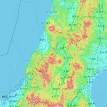
Name: Préfecture de Yamagata topographic map, elevation, terrain.
Location: Préfecture de Yamagata, Japon (37.73383 139.13822 39.59287 140.64647)
Average elevation: 222 m
Minimum elevation: -3 m
Maximum elevation: 2,198 m
Other topographic maps
Click on a map to view its topography, its elevation and its terrain.