
Gillingham topographic map
Interactive map
Click on the map to display elevation.
About this map
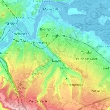
Name: Gillingham topographic map, elevation, terrain.
Location: Gillingham, South East, England, United Kingdom (51.33253 0.52684 51.41326 0.64678)
Average elevation: 59 m
Minimum elevation: -2 m
Maximum elevation: 186 m
Other topographic maps
Click on a map to view its topography, its elevation and its terrain.
Gillingham
United Kingdom > England > Gillingham
Gillingham, Dorset, South West England, England, SP8 4AJ, United Kingdom
Average elevation: 97 m