
Loulé topographic map
Interactive map
Click on the map to display elevation.
About this map
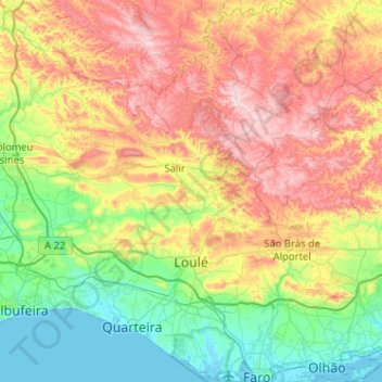
Name: Loulé topographic map, elevation, terrain.
Location: Loulé, Faro, Algarve, Portugal (37.01027 -8.23201 37.41826 -7.87828)
Average elevation: 206 m
Minimum elevation: -2 m
Maximum elevation: 577 m
Other topographic maps
Click on a map to view its topography, its elevation and its terrain.
Moncarapacho e Fuseta
Portugal > Algarve > Moncarapacho e Fuseta
Moncarapacho e Fuseta, Olhão, Faro, Algarve, Portugal
Average elevation: 60 m