
Ústí nad Labem topographic map
Interactive map
Click on the map to display elevation.
About this map
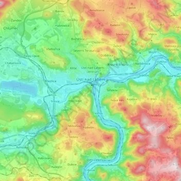
Name: Ústí nad Labem topographic map, elevation, terrain.
Average elevation: 315 m
Minimum elevation: 121 m
Maximum elevation: 674 m
Ústí nad Labem is situated in a mountainous landscape at the confluence of the Bílina and Elbe rivers. Half of Lake Milada lies in the municipal territory. The southern part of the territory lies in the Protected Landscape Area České Středohoří. The highest peak is Široký Vrch with an elevation of 659 metres (2,162 ft)).
Other topographic maps
Click on a map to view its topography, its elevation and its terrain.
Chlumec
Czechia > Northwest > Ústecký kraj
Chlumec, okres Ústí nad Labem, Ústecký kraj, Northwest, 403 39, Czechia
Average elevation: 325 m
bývalý bazén
Czechia > Northwest > Ústecký kraj > Jetřichovice
bývalý bazén, Jetřichovice u Děčína, Jetřichovice, okres Děčín, Ústecký kraj, Northwest, Czechia
Average elevation: 401 m
Andromeda
Czechia > Northwest > Ústecký kraj > Jílové
Andromeda, Sněžník, Jílové, okres Děčín, Ústecký kraj, Northwest, 405 02, Czechia
Average elevation: 564 m