
Salviac topographic map
Interactive map
Click on the map to display elevation.
About this map
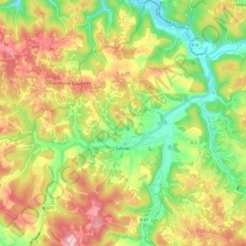
Name: Salviac topographic map, elevation, terrain.
Average elevation: 220 m
Minimum elevation: 124 m
Maximum elevation: 325 m
Other topographic maps
Click on a map to view its topography, its elevation and its terrain.
Rocamadour
France > Occitania > Lot > Rocamadour
Rocamadour, Gourdon, Lot, Occitania, Metropolitan France, 46500, France
Average elevation: 247 m