
南都留郡 topographic map
Interactive map
Click on the map to display elevation.
About this map
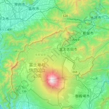
Name: 南都留郡 topographic map, elevation, terrain.
Location: 南都留郡, Préfecture de Yamanashi, Chūbu, Japon (35.35768 138.58186 35.57226 139.11398)
Average elevation: 858 m
Minimum elevation: 102 m
Maximum elevation: 3,757 m
Other topographic maps
Click on a map to view its topography, its elevation and its terrain.