
Poland topographic map
Interactive map
Click on the map to display elevation.
About this map
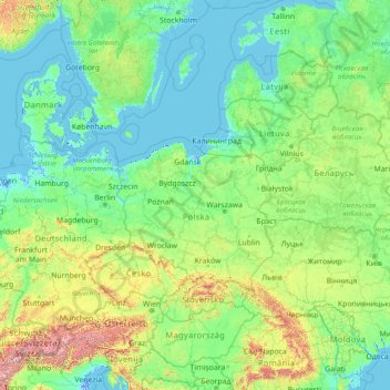
Name: Poland topographic map, elevation, terrain.
Location: Poland (44.71593 11.63442 59.71593 26.63442)
Average elevation: 220 m
Minimum elevation: -5 m
Maximum elevation: 4,155 m
Other topographic maps
Click on a map to view its topography, its elevation and its terrain.
Sudety
Poland > Lower Silesian Voivodeship > Ząbkowice Śląskie County > Starczówek
Average elevation: 293 m
Rysy
Poland > Lesser Poland Voivodeship > Tatra County > Brzegi
It is possible to reach the peak from the Slovak side, starting at Štrbské pleso and passing Chata pod Rysmi, a mountain chalet at an altitude of 2,250 m (7,380 ft). Between November 1 and June 15, the trail and chalet on the Slovak side are closed.
Average elevation: 2,005 m
Wieżyca
Poland > Pomeranian Voivodeship > Kartuzy County > Kolano
Wieżyca (Kashubian Wieżëca, German Turmberg) is a hill located in northern Poland, in the historical region of Kashubia, some 40 kilometers southwest of Gdańsk. With elevation of 329 metres above sea level, it is the highest peak of central and northern Poland. Its top is covered by a forest, and the hill…
Average elevation: 247 m
The Holy Cross
Poland > Świętokrzyskie Voivodeship > Kielce County > Nowa Słupia
Average elevation: 456 m
Końskie
Poland > Świętokrzyskie Voivodeship > Końskie County > Końskie > Końskie
Average elevation: 246 m
Chałupniki
Poland > Lower Silesian Voivodeship > Lubań County > Świecie > Chałupniki
Average elevation: 403 m
Kamiennik / Luboch
Poland > Lower Silesian Voivodeship > Karkonosze County > Szklarska Poręba
Average elevation: 1,184 m
Warsaw
Poland > Masovian Voivodeship > Warsaw > Warsaw
Warsaw lies in east-central Poland about 300 km (190 mi) from the Carpathian Mountains and about 260 km (160 mi) from the Baltic Sea, 523 km (325 mi) east of Berlin, Germany. The city straddles the Vistula River. It is located in the heartland of the Masovian Plain, and its average elevation is 100 m (330 ft)…
Average elevation: 95 m
Sznurki
Poland > Pomeranian Voivodeship > Kartuzy County > Borzestowska Huta > Sznurki
Average elevation: 197 m