
Ooltewah topographic map
Interactive map
Click on the map to display elevation.
About this map
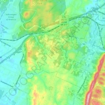
Name: Ooltewah topographic map, elevation, terrain.
Average elevation: 267 m
Minimum elevation: 217 m
Maximum elevation: 389 m
Other topographic maps
Click on a map to view its topography, its elevation and its terrain.
Chattanooga
United States > Tennessee > Hamilton County
Chattanooga, Hamilton County, East Tennessee, Tennessee, United States
Average elevation: 331 m
Signal Mountain
United States > Tennessee > Hamilton County
Signal Mountain, Hamilton County, East Tennessee, Tennessee, 37377, United States
Average elevation: 493 m
East Lake
United States > Tennessee > Hamilton County > Chattanooga > East Ridge
East Lake, East Ridge, Chattanooga, Hamilton County, East Tennessee, Tennessee, 37407, United States
Average elevation: 231 m
Battery Heights
United States > Tennessee > Hamilton County > Chattanooga
Battery Heights, Chattanooga, Hamilton County, Tennessee, 37406, United States
Average elevation: 221 m
Old Farm
United States > Tennessee > Hamilton County > Chattanooga
Old Farm, Chattanooga, Hamilton County, Tennessee, 37419, United States
Average elevation: 261 m
East Brainerd
United States > Tennessee > Hamilton County > Chattanooga
East Brainerd, Chattanooga, Hamilton County, Tennessee, 30726, United States
Average elevation: 225 m