
Waipa District topographic map
Interactive map
Click on the map to display elevation.
About this map
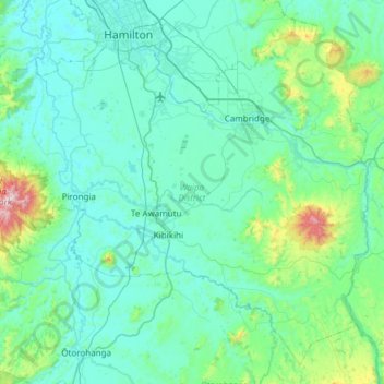
Name: Waipa District topographic map, elevation, terrain.
Location: Waipa District, Waikato, New Zealand (-38.19868 175.05590 -37.76901 175.66046)
Average elevation: 117 m
Minimum elevation: 15 m
Maximum elevation: 920 m
Other topographic maps
Click on a map to view its topography, its elevation and its terrain.
Scotsman Valley
New Zealand > Waikato > Waikato District
Scotsman Valley, Waikato District, Waikato, New Zealand
Average elevation: 108 m
Wentworth Valley
New Zealand > Waikato > Thames-Coromandel District
Wentworth Valley, Thames-Coromandel District, Waikato, New Zealand
Average elevation: 114 m
Eureka
New Zealand > Waikato > Waikato District
Eureka, Waikato District, Waikato, 3287, New Zealand
Average elevation: 49 m
Wyuna Bay
New Zealand > Waikato > Coromandel > Wyuna Bay
Wyuna Bay, Coromandel, Thames Coromandel District, Waikato, 3543, New Zealand
Average elevation: 12 m