
Khan Shaykhun topographic map
Interactive map
Click on the map to display elevation.
About this map
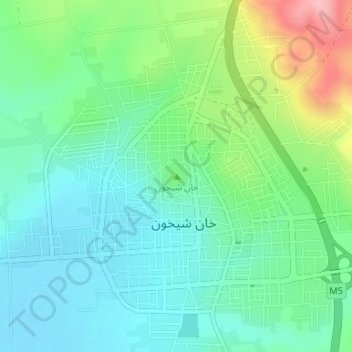
Name: Khan Shaykhun topographic map, elevation, terrain.
Location: Khan Shaykhun, Maarrat al-Nu'man, Idlib, Syria (35.44350 36.64637 35.44360 36.64647)
Average elevation: 374 m
Minimum elevation: 332 m
Maximum elevation: 480 m
Other topographic maps
Click on a map to view its topography, its elevation and its terrain.
Maarrat al-Nu'man
Syria > Idlib > Maarrat al-Nu'man
Maarrat al-Nu'man, Idlib, Syria
Average elevation: 522 m