
Mount Rainier topographic map
Interactive map
Click on the map to display elevation.
About this map
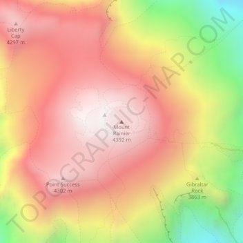
Name: Mount Rainier topographic map, elevation, terrain.
Location: Mount Rainier, Pierce County, Washington, United States (46.85210 -121.75773 46.85220 -121.75763)
Average elevation: 3,912 m
Minimum elevation: 3,157 m
Maximum elevation: 4,378 m
Mount Rainier (/reɪˈnɪər/ ray-NEER), also known as Tahoma, is a large active stratovolcano in the Cascade Range of the Pacific Northwest in the United States. The mountain is located in Mount Rainier National Park about 59 miles (95 km) south-southeast of Seattle. With a summit elevation of 14,411 ft (4,392 m), it is the highest mountain in the U.S. state of Washington and the Cascade Range, the most topographically prominent mountain in the contiguous United States, and the tallest in the Cascade Volcanic Arc.
Other topographic maps
Click on a map to view its topography, its elevation and its terrain.
Tacoma
United States > Washington > Pierce County
Tacoma, Pierce County, Washington, United States
Average elevation: 67 m
Spanaway
United States > Washington > Pierce County
Spanaway, Pierce County, Washington, 98404, United States
Average elevation: 118 m
Charlotte's Blueberry Park
United States > Washington > Pierce County > Tacoma
Charlotte's Blueberry Park, South End, Tacoma, Pierce County, Washington, United States
Average elevation: 121 m
Orting
United States > Washington > Pierce County
Orting, Pierce County, Washington, 98360, United States
Average elevation: 112 m
Steilacoom
United States > Washington > Pierce County
Steilacoom, Pierce County, Washington, 98388, United States
Average elevation: 37 m
Longmire
United States > Washington > Pierce County
Longmire, Pierce County, Washington, United States
Average elevation: 1,041 m
University Place
United States > Washington > Pierce County > Tacoma
University Place, Tacoma, Pierce County, Washington, 98466, United States
Average elevation: 58 m
Fircrest
United States > Washington > Pierce County
Fircrest, Pierce County, Washington, United States
Average elevation: 96 m
Puyallup
United States > Washington > Pierce County
Puyallup, Pierce County, Washington, United States
Average elevation: 66 m
Sumner
United States > Washington > Pierce County
Sumner, Pierce County, Washington, United States
Average elevation: 91 m
Anderson Island
United States > Washington > Pierce County
Anderson Island, Pierce County, Washington, 98303, United States
Average elevation: 20 m
Graham
United States > Washington > Pierce County > Graham
Graham, Pierce County, Washington, United States
Average elevation: 205 m
Paradise
United States > Washington > Pierce County
Paradise, Pierce County, Washington, United States
Average elevation: 1,612 m
Roy
United States > Washington > Pierce County
Roy, Pierce County, Washington, United States
Average elevation: 105 m