
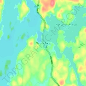
Nestor Falls topographic map
Interactive map
Click on the map to display elevation.
About this map
Name: Nestor Falls topographic map, elevation, terrain.
Average elevation: 337 m
Minimum elevation: 318 m
Maximum elevation: 387 m
Other topographic maps
Click on a map to view its topography, its elevation and its terrain.
Sioux Narrows
Canada > Ontario > Kenora District > Sioux Narrows-Nestor Falls Township
Sioux Narrows, Sioux Narrows-Nestor Falls Township, Kenora District, Northwestern Ontario, Ontario, P0X 1N0, Canada
Average elevation: 329 m
Squirrel Lake
Canada > Ontario > Kenora District > Sioux Narrows-Nestor Falls Township
Squirrel Lake, Sioux Narrows-Nestor Falls Township, Kenora District, Northwestern Ontario, Ontario, Canada
Average elevation: 360 m
Sioux Narrows Provincial Park
Canada > Ontario > Kenora District > Sioux Narrows-Nestor Falls Township
Sioux Narrows Provincial Park, Two Road, Sioux Narrows-Nestor Falls Township, Kenora District, Northwestern Ontario, Ontario, P0X 1N0, Canada
Average elevation: 329 m
Caliper Lake Provincial Park
Canada > Ontario > Kenora District > Sioux Narrows-Nestor Falls Township
Caliper Lake Provincial Park, Highway 71, Sioux Narrows-Nestor Falls Township, Kenora District, Northwestern Ontario, Ontario, Canada
Average elevation: 338 m