
Christ Church topographic map
Interactive map
Click on the map to display elevation.
About this map
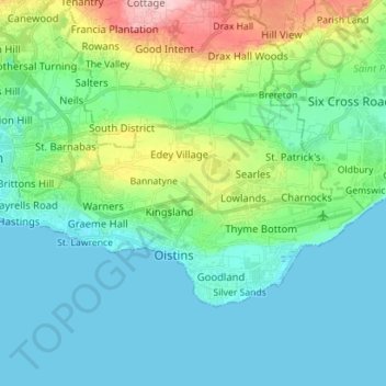
Name: Christ Church topographic map, elevation, terrain.
Location: Christ Church, Barbados (13.04471 -59.61281 13.12559 -59.47233)
Average elevation: 49 m
Minimum elevation: 0 m
Maximum elevation: 227 m
Other topographic maps
Click on a map to view its topography, its elevation and its terrain.
Spring Garden
Barbados > Saint Lucy > Hope > Spring Garden
Spring Garden, Hope, Saint Lucy, BB27144, Barbados
Average elevation: 40 m
Silver Sands
Silver Sands, Christ Church, 17121, Barbados
Average elevation: 11 m
Wilcox
Barbados > Fairy Valley > Wilcox
Wilcox, Fairy Valley, Christ Church, 17121, Barbados
Average elevation: 40 m