
Hatley Castle topographic map
Interactive map
Click on the map to display elevation.
About this map
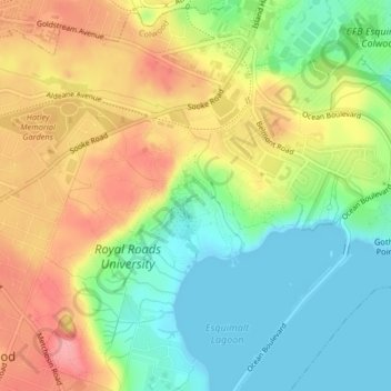
Name: Hatley Castle topographic map, elevation, terrain.
Average elevation: 44 m
Minimum elevation: -2 m
Maximum elevation: 98 m
Other topographic maps
Click on a map to view its topography, its elevation and its terrain.
Esquimalt Harbour
Canada > British Columbia > Colwood
Esquimalt Harbour, Wilfert Road, Colwood, Capital Regional District, British Columbia, V9B 1H8, Canada
Average elevation: 15 m
Fort Rodd Hill and Fisgard Lighthouse National Historic Sites
Canada > British Columbia > Colwood
Fort Rodd Hill and Fisgard Lighthouse National Historic Sites, Colwood, Capital Regional District, British Columbia, Canada
Average elevation: 14 m