
Overberg District Municipality topographic map
Interactive map
Click on the map to display elevation.
About this map
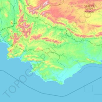
Name: Overberg District Municipality topographic map, elevation, terrain.
Location: Overberg District Municipality, Western Cape, South Africa (-34.83417 18.80954 -33.62197 21.01034)
Average elevation: 290 m
Minimum elevation: -1 m
Maximum elevation: 2,216 m
Other topographic maps
Click on a map to view its topography, its elevation and its terrain.
Durbanville
South Africa > Western Cape > City of Cape Town
Durbanville, City of Cape Town, Western Cape, 7550, South Africa
Average elevation: 157 m
Arniston
South Africa > Western Cape > Overberg District Municipality > Cape Agulhas Local Municipality
Arniston, Cape Agulhas Local Municipality, Overberg District Municipality, Western Cape, South Africa
Average elevation: 13 m
De Vlugt
South Africa > Western Cape > Garden Route District Municipality > George Local Municipality
De Vlugt, George Local Municipality, Garden Route District Municipality, Western Cape, South Africa
Average elevation: 457 m
Cape Town
South Africa > Western Cape > City of Cape Town
Cape Town, City of Cape Town, Western Cape, 8001, South Africa
Average elevation: 53 m
Matjiesfontein
South Africa > Western Cape > Central Karoo District Municipality > Laingsburg Local Municipality
Matjiesfontein, Laingsburg Local Municipality, Central Karoo District Municipality, Western Cape, 6901, South Africa
Average elevation: 972 m
Witzenberg Local Municipality
South Africa > Western Cape > Cape Winelands District Municipality
Witzenberg Local Municipality, Cape Winelands District Municipality, Western Cape, South Africa
Average elevation: 793 m
Wet Lands
South Africa > Western Cape > Cape Winelands District Municipality > Stellenbosch Local Municipality > Stellenbosch
Wet Lands, Stellenbosch Ward 17, Stellenbosch, Stellenbosch Local Municipality, Cape Winelands District Municipality, Western Cape, South Africa
Average elevation: 160 m
Stellenbosch
South Africa > Western Cape > Cape Winelands District Municipality > Stellenbosch Local Municipality
Stellenbosch, Stellenbosch Local Municipality, Cape Winelands District Municipality, Western Cape, 7599, South Africa
Average elevation: 222 m
Signal Hill
South Africa > Western Cape > City of Cape Town > Cape Town
Signal Hill, Cape Town, City of Cape Town, Western Cape, 8051, South Africa
Average elevation: 87 m
Franschhoek
South Africa > Western Cape > Cape Winelands District Municipality > Stellenbosch Local Municipality
Franschhoek, Stellenbosch Local Municipality, Cape Winelands District Municipality, Western Cape, 7690, South Africa
Average elevation: 502 m
Riebeek-Wes
South Africa > Western Cape > West Coast District Municipality > Swartland Local Municipality > Riebeek-Wes
Riebeek-Wes, Swartland Local Municipality, West Coast District Municipality, Western Cape, 7307, South Africa
Average elevation: 262 m
City of Cape Town
City of Cape Town, Western Cape, South Africa
Average elevation: 114 m
Botha
South Africa > Western Cape > Cape Winelands District Municipality > Witzenberg Local Municipality > Botha
Botha, Witzenberg Local Municipality, Cape Winelands District Municipality, Western Cape, South Africa
Average elevation: 322 m
Blue Downs
South Africa > Western Cape > City of Cape Town > Blue Downs
Blue Downs, City of Cape Town, Western Cape, 7129, South Africa
Average elevation: 41 m
Strand
South Africa > Western Cape > City of Cape Town > Strand
Strand, City of Cape Town, Western Cape, 7130, South Africa
Average elevation: 22 m
Plettenberg Bay
South Africa > Western Cape > Plettenberg Bay
Plettenberg Bay, Garden Route District Municipality, Western Cape, 6600, South Africa
Average elevation: 47 m
Knysna Local Municipality
South Africa > Western Cape > Garden Route District Municipality
Knysna Local Municipality, Garden Route District Municipality, Western Cape, South Africa
Average elevation: 353 m
Stellenbosch
South Africa > Western Cape > Stellenbosch Local Municipality > Stellenbosch
Stellenbosch, Stellenbosch Local Municipality, Cape Winelands District Municipality, Western Cape, South Africa
Average elevation: 287 m
Wilderness
South Africa > Western Cape > George Local Municipality > Wilderness
Wilderness, George Local Municipality, Garden Route District Municipality, Western Cape, 6560, South Africa
Average elevation: 69 m
Khayelitsha
South Africa > Western Cape > City of Cape Town
Khayelitsha, City of Cape Town, Western Cape, 7784, South Africa
Average elevation: 26 m
Mitchells Plain
South Africa > Western Cape > City of Cape Town
Mitchells Plain, City of Cape Town, Western Cape, 7785, South Africa
Average elevation: 24 m
Stormberg
South Africa > Western Cape > Garden Route District Municipality > George Local Municipality
Stormberg, George Local Municipality, Garden Route District Municipality, Western Cape, South Africa
Average elevation: 962 m
Table Mountain
South Africa > Western Cape > City of Cape Town > Cape Town
Table Mountain, Cape Town Ward 54, Cape Town, City of Cape Town, Western Cape, 8040, South Africa
Average elevation: 583 m