
Bear Lake County topographic map
Interactive map
Click on the map to display elevation.
About this map
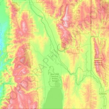
Name: Bear Lake County topographic map, elevation, terrain.
Location: Bear Lake County, Idaho, United States (41.99955 -111.63491 42.60335 -111.04671)
Average elevation: 2,095 m
Minimum elevation: 1,488 m
Maximum elevation: 3,014 m
The county is named after Bear Lake, a large alpine lake at an elevation of 5,924 feet (1,806 m) above sea level. The northern half of the 20-mile-long (32 km) lake is in Idaho, the southern half in Utah. The county was established in 1875 in the Idaho Territory, fifteen years before statehood.
Other topographic maps
Click on a map to view its topography, its elevation and its terrain.
Kuna
United States > Idaho > Ada County
Kuna, Ada County, Idaho, United States
Average elevation: 830 m
Miller Water Table
United States > Idaho > Owyhee County
Miller Water Table, Owyhee County, Idaho, United States
Average elevation: 1,140 m
Big Clear lake
United States > Idaho > Lemhi County
Big Clear lake, Lemhi County, Idaho, United States
Average elevation: 2,617 m
Stanley
United States > Idaho > Custer County
Stanley, Custer County, Idaho, United States
Average elevation: 1,931 m
Chief
United States > Idaho > Valley County
Chief, Valley County, Idaho, United States
Average elevation: 2,249 m
Soda Springs
United States > Idaho > Caribou County
Soda Springs, Caribou County, Idaho, 83276, United States
Average elevation: 1,783 m
Idaho Falls
United States > Idaho > Bonneville County
Idaho Falls, Bonneville County, Idaho, United States
Average elevation: 1,441 m
Snake River
United States > Idaho > Washington County
Snake River, Washington County, Idaho, United States
Average elevation: 643 m
Hagerman
United States > Idaho > Gooding County > Hagerman
Hagerman, Gooding County, Idaho, 83332, United States
Average elevation: 900 m
Boise
United States > Idaho > Ada County
Boise, Ada County, Idaho, 83701, United States
Average elevation: 1,040 m
K Mountain
United States > Idaho > Lemhi County
K Mountain, Lemhi County, Idaho, United States
Average elevation: 2,120 m
Idaho Falls
United States > Idaho > Bonneville County > Idaho Falls
Idaho Falls, Bonneville County, Idaho, 83403, United States
Average elevation: 1,512 m
McCall
United States > Idaho > Valley County > McCall
McCall, Valley County, Idaho, 83638, United States
Average elevation: 1,546 m
Corkscrew Mountain
Corkscrew Mountain, Idaho, United States
Average elevation: 2,459 m
Washington County
Washington County, Idaho, United States
Average elevation: 1,122 m
Oneida County
United States > Idaho > Oneida County
Oneida County, Idaho, United States
Average elevation: 1,678 m
Ruth Lake
Ruth Lake, Adams County, Idaho, United States
Average elevation: 2,218 m
Newdale
United States > Idaho > Fremont County
Newdale, Fremont County, Idaho, 83436, United States
Average elevation: 1,550 m
Sandpoint
United States > Idaho > Sandpoint
Sandpoint, Bonner County, Idaho, 83864, United States
Average elevation: 658 m
Twin Falls County
Twin Falls County, Idaho, United States
Average elevation: 1,404 m
Idaho City
United States > Idaho > Boise County
Idaho City, Boise County, Idaho, 83631, United States
Average elevation: 1,236 m
Mud Lake
United States > Idaho > Jefferson County
Mud Lake, Jefferson County, Idaho, United States
Average elevation: 1,460 m
Snake River
United States > Idaho > Washington County
Snake River, Washington County, Idaho, United States
Average elevation: 643 m
Boise
United States > Idaho > Ada County
Boise, Ada County, Idaho, United States
Average elevation: 974 m
Bonneville County
Bonneville County, Idaho, United States
Average elevation: 1,963 m
Worley
United States > Idaho > Kootenai County
Worley, Kootenai County, Idaho, United States
Average elevation: 830 m
Nampa
United States > Idaho > Canyon County > Nampa
Nampa, Canyon County, Idaho, United States
Average elevation: 764 m
Grangeville
United States > Idaho > Idaho County
Grangeville, Idaho County, Idaho, United States
Average elevation: 1,037 m
Snake River
United States > Idaho > Washington County
Snake River, Washington County, Idaho, 83672, United States
Average elevation: 644 m