
Beaverlodge topographic map
Interactive map
Click on the map to display elevation.
About this map
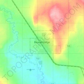
Name: Beaverlodge topographic map, elevation, terrain.
Location: Beaverlodge, Division No. 19, Alberta, T0H 0C0, Canada (55.17062 -119.46867 55.25062 -119.38867)
Average elevation: 735 m
Minimum elevation: 692 m
Maximum elevation: 818 m
Other topographic maps
Click on a map to view its topography, its elevation and its terrain.
Village of Donnelly
Canada > Alberta > Division No. 19
Village of Donnelly, Division No. 19, Alberta, Canada
Average elevation: 594 m
Grande Prairie
Canada > Alberta > Division No. 19
Grande Prairie, Division No. 19, Alberta, Canada
Average elevation: 665 m
La Glace
Canada > Alberta > Division No. 19
La Glace, Division No. 19, Alberta, T0H 2J0, Canada
Average elevation: 738 m