
Bethlehem topographic map
Interactive map
Click on the map to display elevation.
About this map
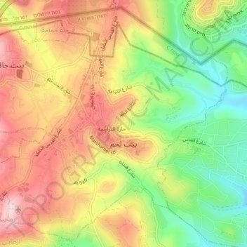
Name: Bethlehem topographic map, elevation, terrain.
Location: Bethlehem, Area A, West Bank, Palestinian Territory (31.69072 35.18236 31.72361 35.22346)
Average elevation: 705 m
Minimum elevation: 569 m
Maximum elevation: 831 m
Bethlehem is located at an elevation of about 775 meters (2,543 ft) above sea level, 30 meters (98 ft) higher than nearby Jerusalem. Bethlehem is situated on the southern portion in the Judean Mountains.
Other topographic maps
Click on a map to view its topography, its elevation and its terrain.
Askar RC (al-Qadeem)
Palestinian Territory > Area A
Askar RC (al-Qadeem), Area A, West Bank, 803, Palestinian Territory
Average elevation: 563 m