
Ghent topographic map
Interactive map
Click on the map to display elevation.
About this map
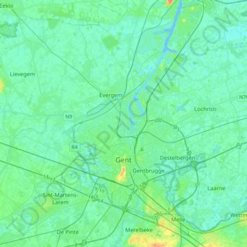
Name: Ghent topographic map, elevation, terrain.
Location: Ghent, Gent, East Flanders, Flanders, Belgium (50.97954 3.57976 51.18889 3.84933)
Average elevation: 7 m
Minimum elevation: -4 m
Maximum elevation: 41 m
Other topographic maps
Click on a map to view its topography, its elevation and its terrain.
Moortsele
Belgium > East Flanders > Gent > Moortsele
Moortsele, Oosterzele, Gent, East Flanders, Flanders, Belgium
Average elevation: 30 m
Ghent
Belgium > East Flanders > Gent > Ghent
Ghent, Gent, East Flanders, Flanders, 24-32, Belgium
Average elevation: 12 m
Knesselare
Belgium > East Flanders > Gent > Aalter > Knesselare
Knesselare, Aalter, Gent, East Flanders, Flanders, 9910, Belgium
Average elevation: 12 m