
Quadeville topographic map
Interactive map
Click on the map to display elevation.
About this map
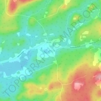
Name: Quadeville topographic map, elevation, terrain.
Average elevation: 333 m
Minimum elevation: 278 m
Maximum elevation: 431 m
Other topographic maps
Click on a map to view its topography, its elevation and its terrain.
Lorwall Lake
Canada > Ontario > Renfrew County > Brudenell, Lyndoch and Raglan
Lorwall Lake, Brudenell, Lyndoch and Raglan, Renfrew County, Eastern Ontario, Ontario, Canada
Average elevation: 401 m
Palmer Rapids
Canada > Ontario > Renfrew County > Brudenell, Lyndoch and Raglan
Palmer Rapids, Brudenell, Lyndoch and Raglan, Renfrew County, Eastern Ontario, Ontario, Canada
Average elevation: 319 m