
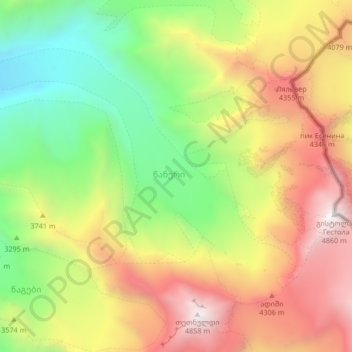
Tsaneri Glacier topographic map
Interactive map
Click on the map to display elevation.
About this map
Name: Tsaneri Glacier topographic map, elevation, terrain.
Average elevation: 3,592 m
Minimum elevation: 2,545 m
Maximum elevation: 4,839 m
Other topographic maps
Click on a map to view its topography, its elevation and its terrain.
Poti
Georgia > Samegrelo-Upper Svaneti > Poti
Poti, Samegrelo-Upper Svaneti, 4400, Georgia
Average elevation: 1 m
Tsalenjikha
Georgia > Samegrelo-Upper Svaneti > Tsalenjikha Municipality > Tsalenjikha
Tsalenjikha, Tsalenjikha Municipality, Samegrelo-Upper Svaneti, Georgia
Average elevation: 241 m
Chkhorotsku
Georgia > Samegrelo-Upper Svaneti > Chkhorotsqu Municipality > Chkhorotsku
Chkhorotsku, Chkhorotsqu Municipality, Samegrelo-Upper Svaneti, Georgia
Average elevation: 201 m
Lekhziri Glacier
Georgia > Samegrelo-Upper Svaneti
Lekhziri Glacier, Mestia Municipality, Samegrelo-Upper Svaneti, Georgia
Average elevation: 3,061 m
Shkhara
Georgia > Samegrelo-Upper Svaneti
Shkhara, Mestia Municipality, Samegrelo-Upper Svaneti, Georgia
Average elevation: 4,334 m
Zhabeshi
Georgia > Samegrelo-Upper Svaneti > Zhabeshi
Zhabeshi, Mestia Municipality, Samegrelo-Upper Svaneti, Georgia
Average elevation: 1,990 m
Ushba
Georgia > Samegrelo-Upper Svaneti
Ushba, Mestia Municipality, Samegrelo-Upper Svaneti, Georgia
Average elevation: 3,640 m