
Ryder Lake topographic map
Interactive map
Click on the map to display elevation.
About this map
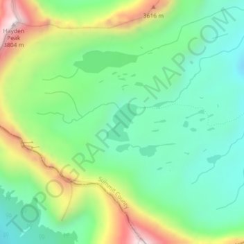
Name: Ryder Lake topographic map, elevation, terrain.
Location: Ryder Lake, Summit County, Utah, United States (40.72273 -110.83064 40.72700 -110.82600)
Average elevation: 3,339 m
Minimum elevation: 3,119 m
Maximum elevation: 3,780 m
Other topographic maps
Click on a map to view its topography, its elevation and its terrain.
Park City
United States > Utah > Summit County
Park City, Summit County, Utah, United States
Average elevation: 2,290 m
Jeremy Ranch
United States > Utah > Summit County
Jeremy Ranch, Summit County, Utah, 84098, United States
Average elevation: 2,048 m
Park City
United States > Utah > Summit County > Park City
Park City, Summit County, Utah, 84060, United States
Average elevation: 2,315 m