
Greenhithe topographic map
Interactive map
Click on the map to display elevation.
About this map
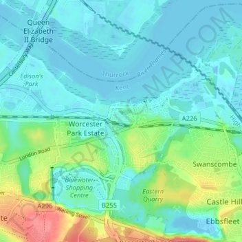
Name: Greenhithe topographic map, elevation, terrain.
Location: Greenhithe, Dartford, Kent, England, DA9 9QR, United Kingdom (51.43074 0.26176 51.47074 0.30176)
Average elevation: 18 m
Minimum elevation: -7 m
Maximum elevation: 80 m
Other topographic maps
Click on a map to view its topography, its elevation and its terrain.
Clement Street
United Kingdom > England > Kent > Dartford > Hawley
Clement Street, Sutton-at-Hone and Hawley, Hawley, Dartford, Kent, England, BR8 7PE, United Kingdom
Average elevation: 47 m
Craylands Gorge
United Kingdom > England > Kent > Dartford > Swanscombe
Craylands Gorge, Swanscombe and Greenhithe, Swanscombe, Dartford, Kent, England, United Kingdom
Average elevation: 19 m
Wilmington
United Kingdom > England > Kent > Dartford
Wilmington, Dartford, Kent, England, United Kingdom
Average elevation: 47 m
Dartford Marshes
United Kingdom > England > Kent > Dartford
Dartford Marshes, Temple Hill, Dartford, Kent, England, United Kingdom
Average elevation: 4 m
Hawley
United Kingdom > England > Kent > Dartford
Hawley, Dartford, Kent, England, DA2 7SA, United Kingdom
Average elevation: 35 m
Worcester Park Estate
United Kingdom > England > Kent > Dartford
Worcester Park Estate, Dartford, Kent, England, DA9 9QG, United Kingdom
Average elevation: 20 m
Bean
United Kingdom > England > Kent > Dartford
Bean, Dartford, Kent, England, DA2 8BG, United Kingdom
Average elevation: 44 m
Heath Side
United Kingdom > England > Kent > Dartford > Bowmans > Heath Side
Heath Side, Wilmington, Bowmans, Dartford, Kent, South East England, England, DA2 7AY, United Kingdom
Average elevation: 39 m
Swanscombe
United Kingdom > England > Kent > Dartford
Swanscombe, Dartford, Kent, England, DA10 0JB, United Kingdom
Average elevation: 21 m
Sutton at Hone
United Kingdom > England > Kent > Dartford
Sutton at Hone, Dartford, Kent, England, DA4 9ET, United Kingdom
Average elevation: 44 m