
Wexford topographic map
Interactive map
Click on the map to display elevation.
About this map
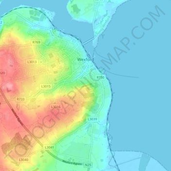
Name: Wexford topographic map, elevation, terrain.
Average elevation: 23 m
Minimum elevation: -4 m
Maximum elevation: 90 m
Other topographic maps
Click on a map to view its topography, its elevation and its terrain.
North West Slob
North West Slob, Ardcavan ED, The Borough District of Wexford, County Wexford, Leinster, Ireland
Average elevation: 1 m
Hollyfort
Hollyfort, The Municipal District of Gorey — Kilmuckridge, County Wexford, Leinster, Ireland
Average elevation: 145 m
Monbay Lower
Monbay Lower, Rossminoge ED, The Municipal District of Gorey — Kilmuckridge, County Wexford, Leinster, Ireland
Average elevation: 136 m
The Municipal District of Gorey — Kilmuckridge
The Municipal District of Gorey — Kilmuckridge, County Wexford, Leinster, Ireland
Average elevation: 58 m
Sow
Sow, Artramon ED, The Borough District of Wexford, County Wexford, Leinster, Y35 R889, Ireland
Average elevation: 47 m
The Borough District of Wexford
The Borough District of Wexford, County Wexford, Leinster, Ireland
Average elevation: 29 m
New Ross
Ireland > County Wexford > New Ross Municipal District
New Ross, New Ross Urban ED, New Ross Municipal District, The Municipal District of New Ross, County Wexford, Leinster, Ireland
Average elevation: 39 m