
Aldergrove Regional Park topographic map
Interactive map
Click on the map to display elevation.
About this map
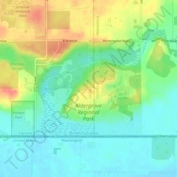
Name: Aldergrove Regional Park topographic map, elevation, terrain.
Average elevation: 64 m
Minimum elevation: 40 m
Maximum elevation: 104 m
Other topographic maps
Click on a map to view its topography, its elevation and its terrain.
Langley Township
Canada > British Columbia > Metro Vancouver Regional District > Township of Langley > Langley Township
Langley Township, Township of Langley, Metro Vancouver Regional District, British Columbia, V2Y 1P0, Canada
Average elevation: 37 m