
Riley Lake topographic map
Interactive map
Click on the map to display elevation.
About this map
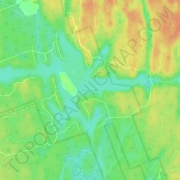
Name: Riley Lake topographic map, elevation, terrain.
Average elevation: 258 m
Minimum elevation: 238 m
Maximum elevation: 278 m
Other topographic maps
Click on a map to view its topography, its elevation and its terrain.
Doe Lake
Canada > Ontario > Muskoka District > Gravenhurst
Doe Lake, Gravenhurst, District Municipality of Muskoka, Muskoka District, Central Ontario, Ontario, Canada
Average elevation: 271 m
Kahshe Lake
Canada > Ontario > Muskoka District > Gravenhurst
Kahshe Lake, Gravenhurst, District Municipality of Muskoka, Muskoka District, Central Ontario, Ontario, P0E 1T0, Canada
Average elevation: 246 m
Three Mile Lake
Canada > Ontario > Muskoka District > Gravenhurst
Three Mile Lake, Gravenhurst, District Municipality of Muskoka, Muskoka District, Central Ontario, Ontario, Canada
Average elevation: 263 m