
Sparks Lake topographic map
Interactive map
Click on the map to display elevation.
About this map
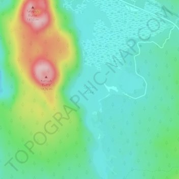
Name: Sparks Lake topographic map, elevation, terrain.
Location: Sparks Lake, Deschutes County, Oregon, United States (43.99887 -121.75166 44.03024 -121.73314)
Average elevation: 1,696 m
Minimum elevation: 1,632 m
Maximum elevation: 1,858 m
Other topographic maps
Click on a map to view its topography, its elevation and its terrain.
Sunriver
United States > Oregon > Deschutes County
Sunriver, Deschutes County, Oregon, 97707, United States
Average elevation: 1,312 m
Lewis Glacier
United States > Oregon > Deschutes County
Lewis Glacier, Deschutes County, Oregon, United States
Average elevation: 2,604 m
Three Sisters
United States > Oregon > Deschutes County
Three Sisters, Deschutes County, Oregon, United States
Average elevation: 2,526 m
Bend
United States > Oregon > Deschutes County
Bend, Deschutes County, Oregon, United States
Average elevation: 1,121 m