
Sturgeon River topographic map
Interactive map
Click on the map to display elevation.
About this map
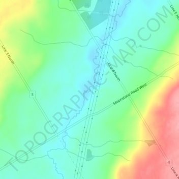
Name: Sturgeon River topographic map, elevation, terrain.
Location: Sturgeon River, Oro-Medonte, Simcoe County, Ontario, Canada (44.62433 -79.73625 44.63793 -79.72790)
Average elevation: 255 m
Minimum elevation: 222 m
Maximum elevation: 323 m
Other topographic maps
Click on a map to view its topography, its elevation and its terrain.
Hawkestone
Canada > Ontario > Oro-Medonte
Hawkestone, Oro-Medonte, Simcoe County, Central Ontario, Ontario, L0L 1T0, Canada
Average elevation: 240 m