
Mulgrave-et-Derry topographic map
Interactive map
Click on the map to display elevation.
About this map
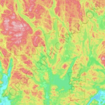
Name: Mulgrave-et-Derry topographic map, elevation, terrain.
Location: Mulgrave-et-Derry, Papineau, Outaouais, Quebec, Canada (45.70703 -75.50914 45.86920 -75.21777)
Average elevation: 277 m
Minimum elevation: 132 m
Maximum elevation: 463 m
Other topographic maps
Click on a map to view its topography, its elevation and its terrain.
Réserve écologique de la Forêt-la-Blanche
Canada > Quebec > Papineau > Mulgrave-et-Derry
Réserve écologique de la Forêt-la-Blanche, Mulgrave-et-Derry, Papineau, Outaouais, Quebec, Canada
Average elevation: 243 m